
Understanding Topographical Surveys: Key Concepts
Topographical surveys, often referred to as land surveys or topo surveys, provide detailed insights into land formations and features, both natural and man-made. In the rapidly evolving fields of construction and urban planning, having accurate data on terrain is crucial for project success. These surveys are not just an optional extra; they are a foundational element that affects the planning and execution of any development project. When exploring options, Topographical surveys offer comprehensive insights that can fundamentally impact the viability of your project.
What is a Topographical Survey?
A topographical survey is a detailed, scale-based mapping process that depicts the contours and physical characteristics of a parcel of land. This includes the altitude of the landscape, the layout of existing structures, vegetation types, and any other significant features such as bodies of water, roads, and pathways. These surveys are typically produced through a combination of modern surveying technology—ensuring high accuracy and reliability in data collection.
Importance of Topographical Surveys in Construction Projects
Topographical surveys are vital for several reasons. They provide the necessary information that architects and engineers rely on to develop safe and effective designs. By understanding the land’s characteristics, construction teams can avoid potential issues, reduce costs, and adhere to legal requirements set forth by local planning authorities. This information not only supports the design phase but also serves as essential data for obtaining planning permissions.
Alternative Names for Topographical Surveys
In the UK, topographical surveys may also be referred to by various names, including terrain surveys, site surveys, and contour surveys. While often used interchangeably, specific terminologies might evoke slight differences in the context of surveying practices or purposes, emphasizing the importance of clarifying your needs when seeking these services.
Why Topographical Surveys are Essential
Topographical surveys provide numerous benefits across different stages of planning and construction, making them indispensable for any development project.
Benefits for Architects and Engineers
For architects and engineers, the accuracy provided by topographical surveys enables them to create designs that are not only aesthetically pleasing but also functional and safe. By understanding the site’s topography, professionals can design buildings, roads, and drainage systems that complement the natural landscape, mitigating potential structural issues down the line.
Support for Planning Applications
Typically, local councils require evidence of a comprehensive topographical survey to approve planning applications. This documentation demonstrates how proposed developments align with existing land features and complies with regulations. Consequently, a thorough topographical survey can not only speed up the planning process but also significantly enhance approval rates.
Identifying Site Constraints and Hazards
Topographical surveys reveal critical information regarding elevation changes, flood zones, and other potential hazards that could impact construction. Early identification of these constraints allows for tailored solutions to avoid costly adjustments during the building phase. Additionally, such foresight can enhance overall site safety and risk management strategies.
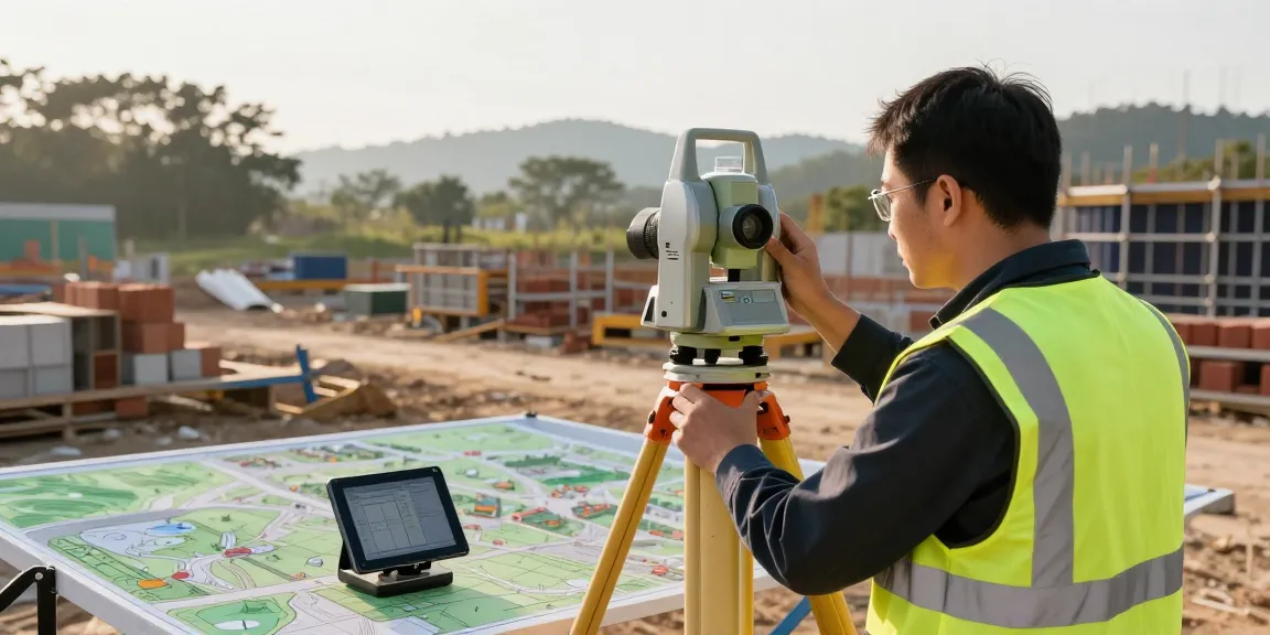
Equipment Used in Topographical Surveys
The accuracy and reliability of a topographical survey largely depend on the equipment used during the data collection phase. Modern technology allows surveyors to achieve high precision, characterizing the landscape effectively.
Overview of Surveying Instruments
Surveyors utilise various instruments, including total stations, levels, and GPS devices, to gather accurate information about a site. These tools work together to ensure that data is collected thoroughly, providing the foundation necessary for all subsequent planning and construction work.
Modern Technologies in Topographical Surveying
Innovation in surveying technology has transformed traditional practices. For instance, 3D laser scanners (LiDAR) capture millions of data points, facilitating detailed 3D models of complex terrains. Drones, in particular, have revolutionised surveying by allowing for aerial data collection in hard-to-reach areas, making the surveying process more efficient and comprehensive.
Choosing the Right Equipment for Your Project
The selection of surveying equipment should align with the specifics of your project. Elements such as site size, complexity, and required detail influence what tools are best suited. Engaging a professional surveying service ensures the right technology is applied, optimising the efficiency and quality of your topographical survey.
Getting a Topographical Survey: Process and Costs
Engaging in the topographical survey process involves several clear steps that can lead you smoothly from initial inquiry to receiving your completed survey documentation.
Steps to Commission a Topographical Survey
The process typically begins with an initial consultation, where prospective clients discuss their requirements and expectations with a surveying firm. Following this, a site visit is arranged to assess conditions before finalising project specifics, costs, and timelines. It’s crucial to ensure that all your needs are clearly communicated to obtain accurate results.
Understanding Pricing and Costs
The cost of a topographical survey can vary significantly based on several factors, including the complexity of the site, the level of detail required, and geographic location. Most residential plots start from around £450, while larger sites can exceed £1,500. Obtaining a tailored quote is advisable, providing clarity on your specific needs without hidden fees or unexpected costs.
Free Quote and Consultation Options
Many professional surveying companies, including ours, offer complimentary consultations, allowing you to discuss your project and obtain a free quote. This can be an invaluable opportunity to ask questions and gain insights into how a topographical survey will benefit your project.
Topographical Surveys: FAQ
What is shown on a topographical survey?
A topographical survey includes crucial data, such as the elevation of land features, existing structures, vegetation types, and hydrological characteristics. This information forms a foundational basis for planning and design processes.
How much does a topographical survey cost?
In the UK, costs can range from £450 to £4,000, depending on various factors such as site size and complexity. It’s vital to seek detailed quotes from surveyors to understand what is included in the pricing.
Do I need a topographical survey for my project?
For construction and development projects, a topographical survey is typically essential. It provides the necessary data that influence design and compliance with local regulations, supporting your project’s overall success.
Who benefits from a topographical survey?
Topographical surveys benefit a wide array of stakeholders, including architects, engineers, planners, and developers. Essentially, anyone involved in land development or construction will find value in the insights provided by such surveys.
How do I choose a topographical survey service?
When selecting a topographical survey service, consider factors such as expertise, technology used, and reviews from previous clients. A reputable service will understand local regulations and have a good track record of delivering precise and valuable survey data.